McDonald County, Missouri · Elk River Hills · Ozark Highlands

The Elk River Hills,
by gravel.

With more than 75 rated routes and over 3,000 miles of backcountry gravel riding, all accessible from a central trailhead and 14 satellite hubs across Southwest Missouri and Northwest Arkansas, the Elk River Hills Gravel Circuit stands among the nation’s most scenic and extensive gravel cycling destinations.

Browse a free, community route library below — filter by distance, climb, surface, and ski-style difficulty, then load any route straight to your GPS.

75+Routes
6–320 MilesRoute Distances
4 Difficulty TiersGreen→Dbl Black
Basecamp · The TrailheadElk River Hills TrailheadThe heart of the network — public parking, route maps, and the Elk River Hills Campground just across the gravel road.
Elk River Hills Gravel Circuit logo
OZARK GRAVEL

THE LANDSCAPES THAT DEFINE THE CIRCUIT

Route Library
Difficulty
Distance
Surface
Type
Hub / Trailhead
What do the difficulty tiers mean?
Green Beginner

Gentle grades and shorter distances. First gravel rides, families, easy spins.

Blue Intermediate

Moderate mileage and climbing. Most hub connectors ride Blue.

Black Advanced

Long, steep, or remote — often all three. Self-sufficiency required.

◆◆
Dbl Black Expert

Expert epics: the circuit’s biggest days, from just under 40 miles to 320.

Sort
Map keyStarts at the Elk River Hills TrailheadStarts away from the main trailhead
The Network

Map out the circuit

The network spreads across McDonald County and over the state line into Northwest Arkansas — its main trailhead and 14 satellite hubs stitched together by connector routes. Explore it all at once: pan, zoom, and tap any line to open it on Ride with GPS.

Interactive network map

All 75+ routes on one pannable, zoomable map — activating the moment the collection is published on Ride with GPS.

75+ routes · 3,000+ miles · 1 trailhead + 14 hubs

Every route is drawn clean — across all 75, not one crosses its own path. No knots, no X's.

The Trailhead

Basecamp for the whole circuit

At the center of the network sits the Elk River Hills Trailhead — land opened for public use, with parking and route details. It's the place to get your bearings, leave the car, and roll out.

MISSOURI ARKANSAS Elk River Indian Creek Little Sugar Creek Buffalo Creek Mike's Creek Butler Creek Big Sugar Creek Flat Creek South Indian Creek Shoal Creek Beaver Lake Flag Spring Conservation Area Huckleberry Ridge Conservation Area Pea Ridge Nat'l Military Park Big Sugar Creek State Park Noel 30.8 mi Neosho 29.3 mi Gravette 29.3 mi Goodman 26.1 mi Bentonville 24.1 mi Anderson 22.7 mi Rogers 26 mi Cassville 26.2 mi OZ Trails 18.8 mi Pineville 18.1 mi Jane 15.3 mi Sugar Creek Road 17.6 mi Pea Ridge 14.4 mi Back 40 12.9 mi ELK RIVER HILLS TRAILHEAD N 0 5 mi
The circuit at a glance — every hub and its connector distance in to the Elk River Hills Trailhead.
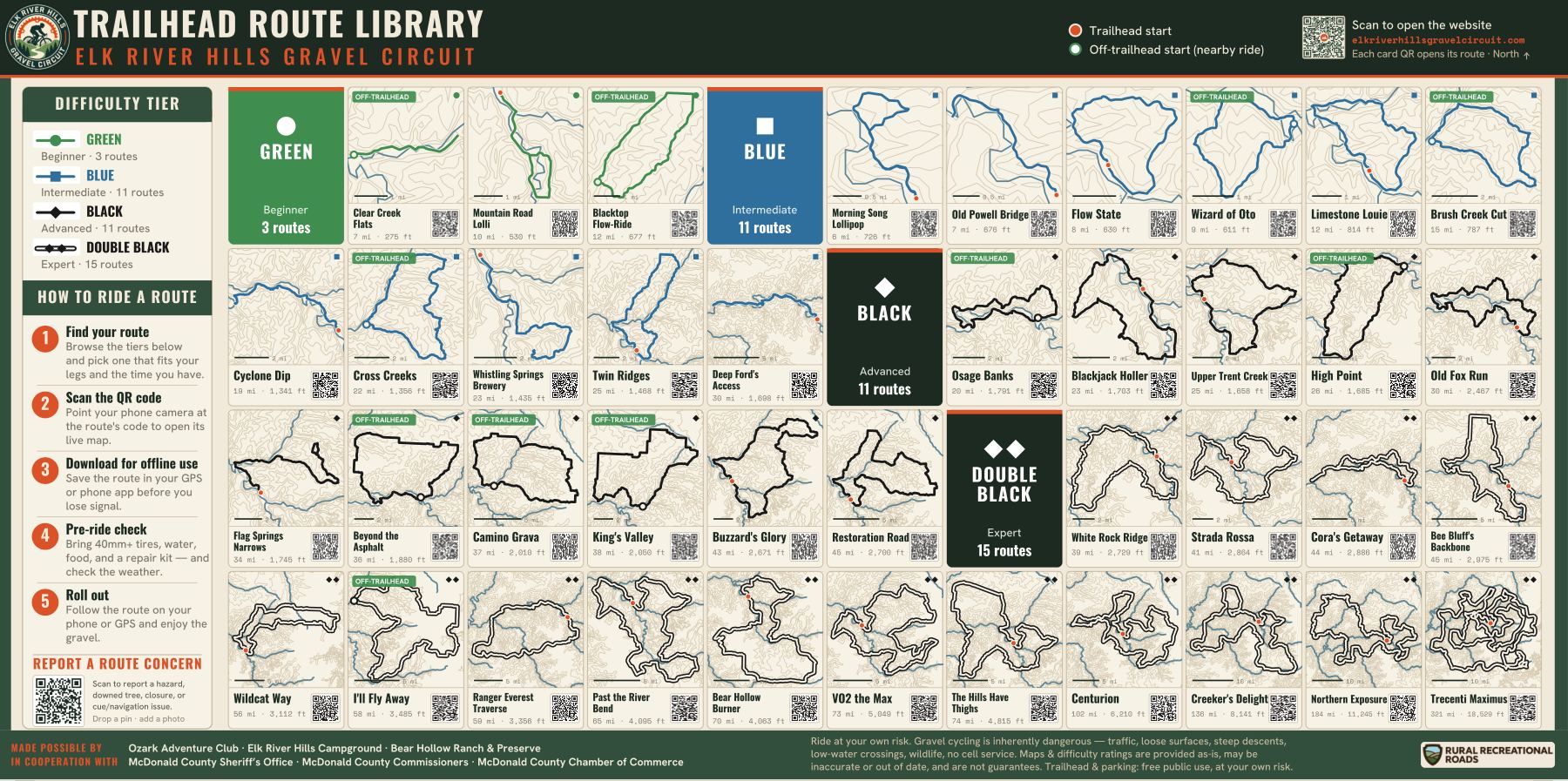
The printed Trailhead Route Library sign: the full circuit basemap with every route card, distances, difficulty tiers, and scan-to-ride QR codes
The Trailhead Route Library — the large-format sign at the trailhead, mapping every route that starts at or near the Trailhead.
Elk River Hills Campground sign: amenities, nightly rates, and reservation info for the basecamp campground on Big Sugar Creek
Elk River Hills Campground & Ozark Adventure Club — the circuit’s ground zero, opening 2026 on Big Sugar Creek.

Across the gravel road, a public campground is taking shape — the Elk River Hills Campground. Its planned amenities read like a bikepacker's wish list — elevated platforms for primitive tent camping, a shower and restroom facility, a pub and general store, direct Big Sugar Creek access, Sprinter van and RV hookups, and even a grass runway for fly-in campers. Together, the trailhead and campground are built to be the circuit's basecamp — a place to start, resupply, and rest. Details and reservations at elkriverhillscampground.com.

The Elk River Hills Gravel Circuit was created by the founders of the Ozark Adventure Club — a private members’ club spanning 1,000+ Ozark acres with two miles of private Big Sugar Creek frontage, spring-fed lakes, cabins and a lodge, guided group rides, on-site cycling support, and fly-in access. It’s the official home of the Big Sugar Cycling Club and the driving force behind opening this country to gravel riders. Learn more at ozarkadventureclub.com.

The Hub Network

Ride in from your town

The circuit reaches well beyond its main trailhead. 14 satellite hubs across Southwest Missouri and Northwest Arkansas feed into it by connector route, so you can ride in from close to home.

Southwest Missouri · 7

Jane
15.3 mi to the trailhead
Maps go live August 2026
Pineville Square
18.1 mi to the trailhead
Maps go live August 2026
Anderson
22.7 mi to the trailhead
Maps go live August 2026
Goodman
26.1 mi to the trailhead
Maps go live August 2026
Cassville Square
26.2 mi to the trailhead
Maps go live August 2026
Crowder Neosho
29.3 mi to the trailhead
Maps go live August 2026
Noel
30.8 mi to the trailhead
Maps go live August 2026

Northwest Arkansas · 7

Back 40 Trailhead
12.9 mi to the trailhead
Maps go live August 2026
Pea Ridge
14.4 mi to the trailhead
Maps go live August 2026
Sugar Creek Road
17.6 mi to the trailhead
Maps go live August 2026
OZ Trails Bike Park
18.8 mi to the trailhead
Maps go live August 2026
Bentonville Square
24.1 mi to the trailhead
Maps go live August 2026
Historic Downtown Rogers
26 mi to the trailhead
Maps go live August 2026
Gravette
29.3 mi to the trailhead
Maps go live August 2026
Multi-day & Bikepacking

Go long, camp, go again

The circuit's biggest loops are bikepacking objectives in their own right — 5 routes past the hundred-mile mark, topping out at the 320-mile Trecenti Maximus. Make the Elk River Hills Trailhead your basecamp at the center of the network: as the Elk River Hills Campground takes shape across the road, you'll be able to ride a hundred-plus-mile loop, then return to showers and resupply before rolling out again. Prefer to go self-supported? Several routes pass designated camping areas in the Flag Spring Conservation Area — check the area's current rules and permits before you pitch.

Camp across the road →

320.6miles
Trecenti Maximus ◆◆Dbl Black
18,529 ft climb · 73% gravel · Loop
Maps go live August 2026
239.6miles
Outer Limits ◆◆Dbl Black
12,697 ft climb · 49% gravel · Loop
Maps go live August 2026
183.8miles
Northern Exposure ◆◆Dbl Black
11,224 ft climb · 55% gravel · Loop
Maps go live August 2026
135.6miles
Creeker's Delight ◆◆Dbl Black
8,141 ft climb · 82% gravel · Loop
Maps go live August 2026
101.6miles
Centurion ◆◆Dbl Black
6,210 ft climb · 66% gravel · Loop
Maps go live August 2026
A group ride on a gravel county road in the Elk River Hills
The Region · McDonald County, Missouri

Where the Ozarks turn to gravel

Tucked into the far southwest corner of Missouri, McDonald County is where the Ozark Highlands break into ridges, hollows, and the clear water of the Elk River and its tributaries — Big Sugar Creek, Indian Creek, Buffalo Creek.

It's a landscape built for gravel: hundreds of miles of quiet county roads winding through hardwood timber, pasture, and low-water crossings, with climbs that earn the views and descents that pay you back.

This is terrain that rewards every kind of effort. Whether you've got an hour, an all-day epic, or a multi-day bikepacking trip in your legs, the hills are open.

Cyclists climbing a gravel ridge road with bikepacking bags
Getting Here

Fly In to Ride

Land in the Ozarks and be on the gravel within minutes. The Ozark Adventure Club maintains a privately owned airstrip open to public aviation use — part of the Fly OZ backcountry airstrip network across Northwest Arkansas, Northeast Oklahoma, and Southwest Missouri — a fly-in gateway to the heart of the Elk River Hills Gravel Circuit.

See the OAC airstrip →

Rider Info

Before you roll

Get rolling — from site to start
1

Find your route

Filter by tier, distance, surface, and max grade, then check the card's stats and gravel bar to match your legs and the time you've got.

2

Open on Ride with GPS

Tap the route's button to open its full map, turn-by-turn cues, and elevation profile on Ride with GPS.

3

Download for offline

Get the free Ride with GPS app, save the route, and download it for offline use on wifi — coverage out here is patchy.

4

Gear up & get there

Park at the Elk River Hills Trailhead. Bring 40mm+ tires, water, food, and a repair kit — and check the weather.

5

Roll out

Follow the route on your phone or GPS and enjoy. Leave gates as you found them, and wear blaze orange in hunting season.

Difficulty tiers

Every route wears a ski-style badge — Green, Blue, Black, Double Black — that weighs distance, climbing, steepness, and how much rough gravel you’ll cover. A short route can still wear a hard badge.

Green Beginner

Gentle grades and shorter distances. First gravel rides, families, easy spins.

Blue Intermediate

Moderate mileage and climbing. Most hub connectors ride Blue.

Black Advanced

Long, steep, or remote — often all three. Self-sufficiency required.

◆◆
Dbl Black Expert

Expert epics: the circuit’s biggest days, from just under 40 miles to 320.

Ratings are our own judgment and are offered to help you choose — they are not a guarantee of safety, conditions, or suitability. Read the card stats, and use your own judgment on the day.

Using the library

Filter routes by distance, climb, surface, max grade, or difficulty, then open any route in Ride with GPS to send it to your device. Coverage is patchy out here — download for offline use before you ride.

Surfaces & tires

The gravel bar on each card shows the unpaved share of the route. Expect loose, sometimes chunky county gravel with paved stretches on the town connectors. Most riders are happiest on 40mm or wider gravel tires.

Come prepared

Many routes have no services for long stretches. Carry water, food, a repair kit, and a way to call for help — and watch the weather, since low-water crossings can run high and fast after rain.

Ride respectfully

Stay on public roads, leave gates as you find them, and pack out what you pack in. Some routes cross Missouri Department of Conservation land — wear blaze orange and stay visible during fall hunting seasons.

See something out on the gravel?

Hazard, downed tree, washed-out crossing, closure, or a cue that’s off? Tell us — drop a pin or just name a landmark, add a photo, and we’ll fix the route or post an advisory. Works from the trailhead sign too.

Report a Route Concern